Video
Plate Dynamics [Videorecording]: University of California
Plate tectonics [videorecording] : the puzzle of the continents / Scott Resources
Living Machine: Continental Tectonics and the Earth's Interior [Videorecording]: WQED Pittsburgh
Plate tectonics [Videorecording] : revolution in earth science / Open University.
Weather and Rocks [Videorecording]: Yorkshire TV
Climates of North America [videorecording] / National Film Board of Canada
Earthquakes in Canada [Videorecording]: Canada Energy, Mines and Resource
Geology [videorecording] / Encyclopedia Britannica Films
Five Billion Years [Videorecording]
River Habitat [Videorecording]
Rivers to the Sea [Videorecording]: Canada. National Film Board
Where Does the Rain Go After it Falls? [Videorecording]: Coronet Films
Climates of North America [videorecording] / National Film Board of Canada.
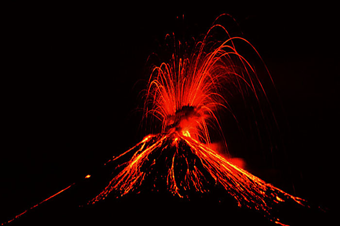
Volcanism [Videorecording]: University of California
Adrift on the Gulf stream [videorecording] / WGBH TV
Latitude [Videorecording]: T V Ontario
The living ocean [videorecording] / National Geographic Society
Planet Earth Series [Videorecording]: WQED Pittsburgh
Weather and Climate [Videorecording]: Tell Me Why?
Cyclone! [videorecording] / National Geographic Society
Il fait beau [Videorecording]: BC Provincial Educ. Media Centre
Hurricane [videorecording] : earth's greatest storm / Scott Resources
Weather II [Videorecording]: Kentucky NBC
Weather I [Videorecording]: Kentucky NBC
Soil Capability Classification [Videorecording]
Living Soil [Videorecording]
The Secrets of Dr. Soil [Videorecording]: Learning Resources & Technology
I Need the Earth and the Earth Needs Me [Videorecording]: General Motors of Canada
Academy Lesson Plans
Geography lesson plans for elementary schools.
http://multimedia2.freac.fsu.edu/academy/
Amethyst Galleries' Mineral Gallery
Mineralogy - OH how I remember that class.
http://mineral.galleries.com/default.htm
An Overview of the Solar System
no description
http://seds.lpl.arizona.edu/nineplanets/nineplanets/overview.html
Arctic Dawn -- The Journeys of Samuel Hearne -- Title Page
no description
http://web.idirect.com/~hland/sh/title.html
Ascension Island Geology
A well done volcanic interface.
http://geowww.gcn.uoknor.edu/www/ascension/ai.htm
Athena, K-12 Curriculum Development
Lesson plans for the earth sciences.
http://inspire.ospi.wednet.edu:8001/
Atlantic Hurricane & Storm Tracking
Get shocked before going here. A real treat for the viewer.
http://hurricane.terrapin.com/
Auroral Imager
U. OF CALGARY. AURORA BOREALIS
http://www.ucalgary.ca/~tstronds/pai/pai.html
Basaltic Blather
Intrusive igneous rock.
http://weber.u.washington.edu/~preiners/
Blackcomb Glaciers - Main
The formation and evolution of a glacier. Good site.
http://www.whistler.net/glacier/
Bright Edges of the World
The earth's evolving drylands
http://drylands.nasm.edu:1995/
Canada's Dynamic Coastline
no description
http://agcwww.bio.ns.ca/geofacts/coast/coast.html
Canadian Great Lakes Shoreline Classification
The Great Lakes Shoreline
http://www.cciw.ca/glimr/metadata/great-lakes-shore-class/intro.html
CoAxial Home Page
A good learning site about ocean ridges. The Juan de Fuca Ridge.
http://www.pmel.noaa.gov/vents/coax/coax.html
Overview of CanSIS
The Canadian Soil Information System.
http://res.agr.ca/CANSIS/_overview.html
Caves of Norway
no description
http://rschp2.anu.edu.au:8080/cave/Norway.html
Charles Darwin - The Origin of Species
The complete text.
http://www.literature.org/Works/Charles-Darwin/origin/
Date and Time Gateway
What time or date is it? Choose your place around the globe.
http://www.bsdi.com/date?US/Mountain
Deforestation and Soil Loss
no description
http://tgl.geology.muohio.edu/Focus/DeforestationandSoilLoss.html
**UBC Earth and Ocean Sciences**
An evolving educational site from U. of B.C. The lithosphere with definitions. Go to Lithoprobe.
http://www.geology.ubc.ca/
Earth Sciences
A descriptive index of sites for earth science and the other sciences. One will find other sites like this on my geographical index page.
http://www-hpcc.astro.washington.edu/scied/earthindex.html
Earth and Environmental Science
Links to geology and soils
http://info.er.usgs.gov/network/science/earth/earth.html
Earthquake Image Information System
Earthquake images=5,800. Soon also to be with documentation.
http://nisee.ce.berkeley.edu/~eqiis/eqiis.html
Earthquake Information
Get the latest co-ordinates of recent earthquakes by latitude and longitude. A good discovery lesson for the student. Gives also their magnitude.Carlton U.
http://www.civeng.carleton.ca/cgi-bin/quakes
EarthWatch Communications, Inc.
Severe weather watches every 10 min.
http://www.earthwatch.com/
What is an El Nino ?
no description
http://www.pmel.noaa.gov/toga-tao/el-nino-story.html
Environment Canada Weather Forecast
Ontario forecasts.
http://www.dow.on.doe.ca/text/fpcn13.wto.htm
Energy and Mines Related Disciplines
The geology of B.C.
http://natural.gov.bc.ca/
EROS-AFO Alaska Ecoregions Map
A site that abounds with information on Alaska's ecosystems. Geology to Vegetation.
http://www-eros-afo.wr.usgs.gov/ecoreg/ecoregmap.html
Example of Landsat TM images for the Moberly Quadrangle (Flooding)
Theme-Flooding of the Mississippi. Images and extent of damage. Flood
http://edcwww2.cr.usgs.gov/moberly.html
Explorer Home Page
This offers over 1000 lesson plans about natural and earth science. Bring your adobe with you.
http://unite2.tisl.ukans.edu/
Flagstaff USGS Terrestial Remote Sensing
Studies include San Francisco ecology change, Desert wind erosion, and the Farallon islands.
http://wwwflag.wr.usgs.gov/USGSFlag/Land/TRS.html
The Geologist's Lifetime Field List
Visit the more important geological sites around the globe.
http://www.uc.edu/~ACOMBTY/geologylist.html
Gemology World - Can. Institute of Gemmology
Learn about gems and where they are produced. Good images of the mines
http://deepcove.com/cig/cig510.html
Gemology & Lapidary Pages
A good site to learn about jemstones.
http://www.teleport.com/~raylc/gems/index.html
Geological Survey of Canada Atlantic Home Page
Ask the Geologist? Go to the site of the week for a breakdown of resources. Educational section as well.
http://agcwww.bio.ns.ca/index.html
Geology Home Page
Predominately another volcanic page from Hawaii. It does have data but must be read with acrobat.
http://www.bishop.hawaii.org/bishop/geology/geology.html
Geology Index
Igneous, Sedimentary and Metamorphic rocks. U. of B.C. Images provided via search engine.
http://www.science.ubc.ca/~geol202/s/202index.html
Geology Resources
Go here for interactive displays, teacher resources.
http://nlu.nl.edu/bthu/nlu/eight/es/Geology.html
geomorphology resources
Landforms and their processes. Wind erosion, landslides, floods.
http://tgl.geology.muohio.edu/gbook/gresources.html
General Earth Science Resources
A site for both student and teacher.
http://nlu.nl.edu/bthu/nlu/eight/es/GeneralEarthScience.html
Global Relief Data
Global relief data and images.
http://www.ngdc.noaa.gov/mgg/global/global.html
GLOBE Visualization Home Page
A very good interactive site for students to learn about the fundamentals of the weather.
http://www.webmaster@globe.gsfc.nasa.gov/globe/
Giovanni Guglielmo's Research Page on Salt Tectonics
A teacher could really put his work to good use if one has the software like Quicktime for Windows. Animation of salt domes and other related processes.
http://www.utexas.edu/research/beg/giovanni/
GIF image
Radar image of the weather for North America.
http://accuwx.com/www/graphics/unmcrus.gif
GSC Atlantic's Earth Science Site of the Week
Offers good leads by category. Economic Geology to Imaging as well a list of good educational sites.
http://agcwww.bio.ns.ca/misc/geores/sotw/sotw.html
Hurricane Tracts
The latitude and longitude of the most recent hurricane. A good plotting exercise.
http://thunder.met.fsu.edu/explores/Tropical/td7/latlon.html
Image Gallery-U. of B.C.
Type in a concept or the name of a geologic structure. Image is returned. Maybe. Type a generalized term such as igneous for better results.
http://www.science.ubc.ca/~geol202/s/cgi-bin/gallery.cgi
INTELLICAST: Canada Satellite
no description
http://www.intellicast.com/weather/intl/cansat/
INTELLICAST: Detroit Weather
no description
http://www.intellicast.com/weather/dtw/
INTELLICAST: detroit NEXRAD
no description
http://www.intellicast.com/weather/dtw/nexrad/
INTELLICAST: buffalo NEXRAD
A better spot for Woodstonians, Londoners, and people from Taranta.
http://www.intellicast.com/weather/buf/nexrad/
INTELLiCast: Help
Provides answers to common questions. TIME- Usually the last nexrad was on the hour. Greenwich Mean Time G.M.T. Count back 5 hours during daylight savings time. Your brouser may also have a glitch. Go here to check it out.
http://www.intellicast.com/help/#GMT
AN INTRODUCTION TO COAL
A very well prepared document regarding the formation and classification of coal.
http://www.newcastle.edu.au/department/gl/cfkd/undp.htm
Joel's hurricane page
no description
http://www.jgds.com/hurricane/
Julian Thompson's Ph.D Abstact
Wetlands of Nigeria.
http://albion.geog.ucl.ac.uk/~jthompso/phd.html
Jurassic Reef Park,
A very detailed description on the formation of ancient reefs. Includes images. Well done.
http://www.uni-stuttgart.de/UNIuser/igps/edu/JRP/JRP_english1.html
Lightning Detector in Space
World lightning facts, figures and maps.
http://wwwghcc.msfc.nasa.gov/otd.html
LLNL Environmental Programs Home Page
The Lawrence Livermore Library offering seismic, geology, environmental hazards research. Bring your 3.5 disk.
http://www-ep.es.llnl.gov/www-ep/ep-home.html
Marine Geology & Geophysics- N.O.A.A.
Ocean floor data and images. Includes the Great Lakes.
http://www.ngdc.noaa.gov/mgg/wdcamgg/
Marine Geology & Geophysics Databases
no description
http://www.ngdc.noaa.gov/mgg/mggonline.html
Marine Geology
no description
http://www.ngdc.noaa.gov/mgg/whatsnew.html
Mackenzie River Studies
GEWEX- Research and data from the Arctic. Climate, water basins. Some information requires acrobat.
http://www.on.doe.ca/GEWEX/gewex_homepage.html
METALS PRICES
Gives current stock prices and information of the leading metals. ie. gold, silver, lead and copper.
http://www.trellgroup.se/trellgroup/PRI.html
Mines & Energy, Geological Survey
This is a terrific site from NFLD.. How does one stake a claim? Maps, minerals and even lesson plans for teachers. Thanks.
http://www.geosurv.gov.nf.ca/
MTU Volcanoes Page
A good site for volcano information and updates.
http://www.geo.mtu.edu/volcanoes/
Museum of Paleontology Public Exhibits
Paleontology is my love. A good interactive site offering interactive displays through Geologic Time. U. of California
http://www.ucmp.berkeley.edu/exhibit/exhibits.html
NCDC Home Page
Climate data and graphs for any country including Canada. Get max. and min. variables by month for Barrie, Ont. What a storehouse.
http://www.ncdc.noaa.gov/
NRCan - Welcome
Natural Resources Canada
http://www.NRCan.gc.ca/home/page2_e.htm
North American Skies Home Page
When will the next shower be?
http://members.aol.com/astroclass/index.htm
Ocean Planet Homepage
no description
http://seawifs.gsfc.nasa.gov/ocean_planet.html
Oceanography Resources
A good link to the Great Barrier Reef and Interactive lessons. Links to lesson plans for teachers.
http://nlu.nl.edu/bthu/nlu/eight/es/Oceanography.html
On-line Earth Science Journals
Extensive list. There always seems to be a hangup for the Canadian Journals.
http://www.ncpgg.adelaide.edu.au/journals.htm
Past Global Change in Western North America (EiS)
An interactive site for students to visualize past global change patterns.
http://earth.agu.org/kosmos/anders.html#PR
Planetary Fact Sheets
Facts and figures on all planets within our solar system.
http://nssdc.gsfc.nasa.gov/planetary/planetfact.html
The Plankton Net
A lot of information about plankton. Go to homepages for documentation and images for pictures of marine mammals.
http://www.uoguelph.ca/zoology/ocean/frame.htm
Rincon de la Vieja
Volcanoes of Costa Rica.
http://www.utexas.edu/cons/geo/barker/kempter/rincon.html
Rob's Granite Page
A reasearcher who is not a stone face. A terrific geology site that makes it fun to learn. Good links. A real igneous place.
http://uts.cc.utexas.edu/~rmr/
San Fransisco Bay Landsat TM Main Page
Environmental change in San Francisco. A full descriptive study using satellite imagery.
http://wwwflag.wr.usgs.gov/TRS/projects/SFBay/
Slovene karst
Karst topography in Europe.
http://www.ijs.si/slo/country/geo/karst/karst.html
Smithsonian
Natural history links including volcano updates and maps.
gopher://nmnhgoph.si.edu/
Sparrow Project Home Page
The geologic timeline, periodic table and why are golf balls dimpled?
http://www.con.wesleyan.edu/~eric/sparrow/Sparrow.html
SSEC Real Time Data
GOES 30 min. update on your weather.
http://www.ssec.wisc.edu/data/index.html#top
Storm Prediction Center
Go to data archive for when and where tornadoes have been active in the U.S..
http://www.nssl.uoknor.edu/~spc/
Structural Geology on the Web
no description
http://hercules.geology.uiuc.edu/~schimmri/geology/structure.html
talk.origins FAQ Archive
Views regarding the ultimate question.
http://rumba.ics.uci.edu:8080/origins/faqs.html
TEC Online Information Resources
The U.S. army . Good insight and mapping . Excellant information on EL NINO
http://www.tec.army.mil/tec_organization.html
The 4 C's
Learn about diamonds.
http://www.teleport.com/~raylc/master/four_c.html
The Journey North
An adventure to the arctic.
http://ics.soe.umich.edu/ed712/IAPIntro.html
The NASA/JPL Imaging Radar Home Page
Include one of these images in your report or use one of the movies in your lesson. Earth images ie. volcanoes.
http://southport.jpl.nasa.gov/
The Nine Planets
no description
http://seds.lpl.arizona.edu/nineplanets/nineplanets/nineplanets.html
The Polar Regions
The physical and ecological links for the polar regions.
http://www.stud.unit.no:80/~sveinw/arctic/
The Vatnajokull Eruption of October, 1996
Ed usually has the latest on volcanic eruptions.
http://www.geog.ualberta.ca/als/icepics/eruption.htm
The Why Files
Special lessons about science topics. Radiation exposure to genes.
http://whyfiles.news.wisc.edu/
Tornadoes
no description
http://cc.usu.edu/~kforsyth/Tornado.html
Tornado and Storm Research Organisation
A good research site from the U.K.
http://www.zetnet.co.uk/oigs/torro/
Understanding our Planet Through Chemistry
Includes radioactive dating, marsh gases, acid rock deposition from mining, measurement studies.
http://helios.cr.usgs.gov/gips/aii-indx.htm
Uranium Information Centre
Everything one wishes to know regarding the uranium industry around the world. Go to each newsletter to get the latest from each country. Including Canada.
http://www.uic.com.au/
USDA-ARS Wind Erosion Research Unit
no description
http://www.weru.ksu.edu/
U.S. Geological Survey
Geology, water and mapping products. Free software for the advanced geographer .
http://info.er.usgs.gov//
Views Of The Solar System
Complete documentation and images of the planets within our solar system.
http://bang.lanl.gov/solarsys/
Virtual Geomorphology
A very sophisticated site. Some links for high school while most for the university oriented person.
http://hum.amu.edu.pl/~sgp/gw/gw1.htm
Virtual Sun
The chemical and physical makeup of our nearest star.
http://www.astro.uva.nl/michielb/sun/kaft.htm
VGL Front Page
Virtual Geoscience Library. Relief maps, Journals-go to full text.,and data.
http://www.umich.edu/~vgl/index.html
VSC Home Page
Volcanoe information.
http://www.vsc.washington.edu/
VolcanoWorld
A comprehensive site on all aspects of volcanoes around the world.
http://volcano.und.nodak.edu/vw.html
VORTEX- Twister- Tornado
From the Why Files
http://antietam.nssl.uoknor.edu/mosaic_files/vortex.html
The Weather Network - City Weather
Get the latest weather updates by city in Canada.
http://www.theweathernetwork.com/city/city_n.htm
Weather Information Service
Storm Warnings- If it comes from Canada , it will probably be to late. They are now using C.B. ers to transmit funnel clouds. How are politicians save costs to save lives.
http://206.152.142.51:80/weather/#Warning
Weather Information Service
3D Images and links.
http://206.152.142.51:80/weather/#Radar
Welcome to the Natural History Museum home page
An online view of Natural History in London, England.
http://www.nhm.ac.uk/
Weathering and Karst
no description
http://geology.smith.edu/geomorph/Karst.html
Weather Map
The old fashion kind. A good source for GEO. 3A1
http://www.mit.edu:8001/usa.html
The Weather Network Online - Welcome!
no description
http://www.theweathernetwork.com/
Wetland Research Unit, UCL Home Page
no description
http://albion.geog.ucl.ac.uk/~jthompso/
Wind Chill Calculator
no description
http://www.iglou.com/zipper/WindChillCalc.html
Windows to the Universe
Everything one wishes to know about the planets, solar system, and universe. A bit slow even with a 28,800 modem.
http://www.windows.umich.edu/
Zia Design Group/Zia Maps Homepage
Landform maps by U.S. state
http://www.dimensional.com/ziamaps/frame/index.html
Plate Tectonics
Air Photos and diagrams of the lithosphere and its faults.
http://www.seismo.unr.edu/ftp/pub/louie/class/100/plate-tectonics.html
North Eastern U.S. Weather Page
A description of the weather via pressure, wind and temperature satellite images. NE U.S.A. and Canada.
http://www.ems.psu.edu/wx/newx.html
Nova Scotia -geology
The Geologic History of Nova Scotia. Bring your Acrobat Reader.How Plate tectonics has influenced N.S.
http://www.ednet.ns.ca/educ/museum/mnh/nature/nhns/t2/t2-1.htm
GeologyLink
Follow the links for minerals, igneous sedimentary, weathering, folds,faults, glaciers,deserts and much more.
http://www.geologylink.com/toc/
The Thames River
Facts on the Thames River in Ontario.
http://info.london.on.ca/culture/rivfacts.html
SEISMOGRAM-BMY
Get the latest seismogram readouts which tells one about the location and magnitude of the most recent earthquakes.
http://www.geol/binghamton.edu/seismogram.html
Seismic Hazards Risk Centre- Maps
The earthquake risk maps of the U.S. and southern Canada.THERE IS A 1-2% CHANCE OF AN EARTHQUAKE OCCURENCE IN WOODSTOCK WITHIN THE NEXT 50 YEARS.
http://wwwneic.cr.usgs.gov/eq/finmaps.shtml#ceus
The CarbonDating Web
A complete guide to radiocarbon dating.
http://www2.waikato.ac.nz/c14/webinfo/index.html
Overview of New York Geology
The complete guide to the geology of New York state. Includes graphics and maps for the state and portions of Southern Ontario. Terrific documentation but slow- worth the wait.
http://gretchen.geo.rpi.edu/roecker/nys/nys_edu.pamphlet.html
Tsunamis Warning System- B.C.
A good series of documents educating the public about tsunamis and the early warning system for our British Columbia neighbours.
http://hoshi.cic.sfu.ca/~pep/tsunam1.html
Geologic Structure Of North Africa
Topographic and tectonic maps. The evolution of the Atlas mountains. Can be used as a base study for Egypt, Libya, Morroco and the Saharra desert.
http://www.geo.utep.edu/nafr/geo.html
Boreus Project
A study of Canada's boreal forest near Thompson, Manitoba. It has a link to Thompson who's main industry is INCO. Mining.
http://boreas.gsfc.nasa.gov/BOREAS/Sites/NSA.html
Boreus Project
A study of the southern range of Canada's Boreal forest near Prince Albert, Saskatchewan.
http://boreas.gsfc.nasa.gov/BOREAS/Sites/SSA.html
World Tidal Site
The daily tides of both east and west coasts of Canada. Includes Bay of Fundy. I suppose one could view these over a period of a month and make a good comparitive study. Scroll down.
http://tbone.biol.sc.edu/tide/sites_othernorth.html
UNIVERSITY OF WINDSOR
A glossary of geology and mining terms. Some description provided. My good old days were spent in this dept.
http://www.cs.uwindsor.ca/meta-index/courses/96W/61-242/14.htm
Science Web
The Burgess Shale Information page. Good information regarding the rock cycle, paleontology(my love), fossils, plate tectonics. This is a world heritage site in Canada. Don't wear running shoes to walk up there after a rain.
http://scienceweb.dao.nrc.ca/burgess/contents.html
***WW2010- The weather world 2010 project***
Interactive learning about severe weather, thunderstorms, el nino, tornado and hurricane case studies, remote sensing. This is a well done site.
http://ww2010.atmos.uiuc.edu/(Gh)/home.rxml
Canadian Soil Information System (CanSIS)
A database and illustration format for soils found in all regions across Canada. Gives the relationship between glaciation and soil formation. Slope, stream deposition, peat, alluvial, eolian, lacustrine deposits.
http://res.agr.ca/CANSIS/_overview.html
Weather Dogs
Designed for the storm chaser to get the latest weather information from Environment Canada/Canadian Meteorological Centre (hereafter EC/CMC). TORNADOES.
http://taiga.geog.niu.edu/chaser/canada/
The Science Education Gateway
Interactive lesson plans for geography, environmental science and chemistry teachers. Space Science, Light, Cycles, Sun&Earth, Weather, Solar System.
http://www.cea.berkeley.edu/Education/SII/SEGway/seg_noframes.html
Canadian Ice Service
Ice tewrms, climatology, satellite images. Glaciers
http://www.dow.on.doe.ca/ice/home.ice.html
Canadian Ice Service- Links
Access to the Physical Characteristics and Bathymetry Maps of the Great Lakes. Sea surface temperatures, Arctic and Anarctic.
http://www.dow.on.doe.ca/ice/iceinfo/iceweb.html
Glacier Bay
An Interactive Visual tour. Make sure you have the latest netscape navigator with QuickTime.
http://sdcd.gsfc.nasa.gov/GLACIER.BAY/glacierbay.story.html
Gaciers
The formation of and effects of glaciers on people and the landscape.
http://www-nsidc.colorado.edu/NSIDC/EDUCATION/GLACIERS/
The Great Lakes: Snow Machines
Great Lakes Influence On Temperatures, Lake-Effect Snow Belts, How Lake-Effect Snow Develops, A Special Lake-Effect Snow Case.
http://covis.atmos.uiuc.edu/guide/rsteve/html/lakesnow.html
National Snow and Ice Data Center
Snow Glossary
http://www-nsidc.colorado.edu/NSIDC/EDUCATION/SNOW/snow_glossary.html
National Snow and Ice Data Center
Brightness Temperatures, Polar Atmosphere Data, Satellite Imagery, Sea Ice Data, Snow Cover Data.
http://www-nsidc.colorado.edu/NASA/GUIDE/docs/daac_documents/catalog.html
National Snow and Ice Data Center
Recent Events in the Northern Larsen Ice Shelf and Their Importance. Anarctic, glaciation, climate change.
http://www-nsidc.colorado.edu/NSIDC/LARSEN/
Paleontology Without Walls
An online look at Phylogeny -- the "family tree" of life. Geological Time -- the temporal existence of groups of organisms. Evolutionary Thought -- evolutionary topics and scientists in their historical context. fossils, sedimentary rock, limestone, quarries.
http://www.ucmp.berkeley.edu/exhibit/exhibits.html
Geological Hazards
Photos and descriptions of volcanic effects, glacial effects, sedimentary, igneous and metamorphic rocks, mudflows, permafrost effects, rockslides, mine fires, faults, earthquakes, geothermal effects, erosion and asbestos. copy and make a transparency or insert into essay.
http://stargate.jpl.nasa.gov:1080/hazards/hz2_1.html
Natural History Of Nova Scotia
Quarternary, glaciers, Fundy Stade, drumlin fields, glacial striations, Escuminac Ice Centre, Scotian Ice Divide, erratics, moraines, ablation till, glaciofluvial sediments, Scotian Shelf Moraine System, Beaver River Till, residual ice, Ice Age, ice sheet, Sheet Harbour, isostatic uplift, Advocate Harbour, Sable Island
http://www.ednet.ns.ca/educ/museum/mnh/nature/nhns/t3/t3-3.htm
Glaciers
Alpine and Continental Glaciation. Go to glacier1-5 html.
http://147.205.15.81/geology/work/VFT-so-far/glaciers/
CLIMVIS
Graph and Download Data from the World's Weather Data Archive. Includes Canadian cities. Includes historical precipitation data for my hometown!
http://www.ncdc.noaa.gov/onlineprod/drought/xmgr.html
Soil Illustrations In Canada- by region
Soil Landscapes evident around us are the product of soil forming factors acting on surface geological deposits over time. Factors influencing soil formation (or soil development) include kind of parent material, topography (or surface form), climate, vegetation, time and of course the activities of man.
http://res.agr.ca/CANSIS/TAXA/LANDSCAPE/_overview.html
The Soft Earth
A resource listing for Geoscience software available on the Internet. Geology, earth science.
http://atlas.es.mq.edu.au/users/pingram/s_earth.htm
Glacial Geology at the University of Cincinnati,
A graphical database showing glaciers at work and at play.
See also Class Projects - 1995 and Laboratory Reports 1996.
http://tvl1.geo.uc.edu/ice/glacier.html
Oak Ridge National Lab.
The radiocarbon timescale vs the 'real' timescale; A quick background to the last Ice Age; Stepwise regional maps of the world from 20,000 years ago; Sudden climate transitions during the past 130,000 years.
http://www.esd.ornl.gov/ern/qen/nerc.html
A Geologist's Lifetime Field List
A lead to illustrations of volanoes, geysers, floods, faults, glaciers, varves, exfoliation domes, tectonic plates, erratics, stromatolites, calderas, craters and other specific examples of natural formations around the world. Bay of Fundy, Kilimanjaro, Devil's Tower, Tierra del Fuego.
http://www.uc.edu/www/geology/geologylist/index.html
The Virtual Geomorphology
Online research papers for the advanced geographer. Includes topics covering Life on Earth - flow of Energy and Entropy, Open and closed systems, fluvial systems.
http://hum.amu.edu.pl/~sgp/gw/gwsys.htm
***Canadian Landscapes- NRC***
Learn about the geomorphology of the following through pictures and description.Atlantic Provinces, Labrador, Baffin Island, Ellesmere Island, Western Queen Elizabeth Islands, Banks Island, Coats & Mansel Islands, Torngat Mountains, Gaspesie, Northwestern District of Mackenzie, NWT
Hudson Bay Lowlands, Southern Manitoba.
http://sts.gsc.nrcan.gc.ca/page1/landf/canada.htm
***Canadian Landscapes- NRC***
Use their search engine to find examples of terrain across Canada. Esker, fiord, glacier, tombolo, kettles, ice cap, moraine, erractic, frost mound or any other example.
http://sts.gsc.nrcan.gc.ca/page1/landf/index.html
National Snow and Ice Data Center- U. of Colorado
Everything one wishes to know about glaciers.
http://www-nsidc.colorado.edu/NSIDC/EDUCATION/GLACIERS/
NOAA Paleoclimatology Program
A quick primer on the science of Paleoclimatology. Paleoclimatology is the study of past climate. The word is derived from the Greek "paleo-", which means "ancient", and "climate", which is the average pattern of weather. Paleoclimatology is the study of the patterns of ancient weather. global warming, greenhouse effect.
http://www.ngdc.noaa.gov/paleo/education.html
National Snow and Ice Data Center
Recent Events in the Northern Larsen Ice Shelf and Their Importance. climate change, ice shelves.
http://www-nsidc.colorado.edu/NSIDC/LARSEN/
NOAA
NATURAL HAZARDS PHOTOGRAPHS: Landslides, Tsunamis, Mt. St. Helens,Hawaii Volcanism, Volcanoes in Eruption,*Relief Globe Slides*. Includes descriptions.
http://www.ngdc.noaa.gov/cgi-bin/seg/men2html?/usr/online/html/seg/menus/sl
NOAA
NATURAL HAZARDS PHOTOGRAPHS: Earthquake Slides of Mexico City, California, Northern Iran, Earthquake Damage to Transportation Systems and schools and Armenian SSR.
http://www.ngdc.noaa.gov/cgi-bin/seg/men2html?/usr/online/html/seg/menus/sl
NOAA- The National Geophysical Data Center
This site has leads to the National Geophysical Data Center (NGDC) manages environmental data in the fields of marine geology and geophysics, paleoclimatology, solar-terrestrial physics, solid earth geophysics, and glaciology (snow and ice).
http://www.ngdc.noaa.gov/
Geohazards- NRC
Landslides and snow avalanches in Canada, National geological Hazard Synthesis, Geomorphic effects and impacts from July 1996 severe flood in the Saguenay Area.
http://sts.gsc.nrcan.gc.ca/page1/geoh/
Urban Geology- NRC
Urban geology of the National Capital (Ottawa), Surficial materials and terrain features maps of Ottawa. Physiography, moraine, glaciation.
http://sts.gsc.nrcan.gc.ca/page1/urban/
The Quaternary?
"The Ice-Age"
http://www2.tcd.ie/QRA/what.html
Ice Ages- Illinois State U.
What are Ice Ages?
When did Ice Ages occur?
Why do Ice Ages occur?
http://www.museum.state.il.us/exhibits/ice_ages/
Inside Geology- Rob Viens, University of Washington
Learn more about basic concepts in geology? The following chapters will link you to numerous topical class lectures, Web sites, references, news items, organizations.
9.Folds, Faults, and Mountains
10.Earthquakes
11.Geophysical Properties of Planet Earth
12.Plate Tectonics:Creating Oceans and Continents
http://www.geologylink.com/toc/
Inside Geology- Rob Viens, University of Washington
Learn more about basic concepts in geology? The following chapters will link you to numerous topical class lectures, Web sites, references, news items, organizations.
9.Folds, Faults, and Mountains
10.Earthquakes
11.Geophysical Properties of Planet Earth
12.Plate Tectonics:Creating Oceans and Continents.
http://www.geologylink.com/toc/
Inside Geology- Rob Viens, University of Washington
Learn more about basic concepts in geology? The following chapters will link you to numerous topical class lectures, Web sites, references, news items, organizations.
13. Mass Movement
14.Streams and Floods
15.Groundwater
16.Caves and Karst
17.Glaciers and Ice Ages
18.Deserts and Wind Action
19.Shores and Coastal Processes
20.Human Use of the Earth’s Resources
http://www.geologylink.com/toc/
Spitak Earthquake Damage
Background information on Armenia. Geology and geophysics. Main shock. Aftershocks.
http://www.ngdc.noaa.gov/cgi-bin/seg/men2html?/usr/online/html/seg/menus/sp
National Geophysical Data Center
Hazards Slides: Volcanoes ,The Spitak Earthquake of 7 Dec. 1988. Coastal Change Analysis (Chesapeake Bay).
http://www.ngdc.noaa.gov/seg/mainmeta.html
U.S.D.A.- U. S. SALINITY LABORATORY
Leads to soil acidity, FAQ on soil acidity, some publications with adobe and finally the use of Methyl Bromide vs. the ozone depletion.
http://www.ussl.ars.usda.gov/index000.htm
CoVis
Lesson plans for soil testing. Go further down the page for a lead to lesson plans and Mac software for global warming and LUMP ( land use planning- a city in India. )
http://www.covis.nwu.edu/Geosciences/projects/NATIVE_SOIL/student_handouts.
Ahena
Links to mineral equations, full online texts and books for science, geologists, geographers plus software( rock cycle )
http://un2sg1.unige.ch/www/athena/html/science.html
Cybersoils- M.A.Turner, Massey University, New Zealand
AGRICULTURAL IMPACT OF VOLCANO IN N.Z., CONTROLLED-RELEASE FERTILIZERS TO INCREASE EFFICIENCY OF NUTRIENT USE AND MINIMISE ENVIRONMENTAL DEGRADATION, (Worms~~ and vermiculture ??), Cobalt and B12 in USA soils. Oriented towards Soil Science Teaching.
http://www-aghort.massey.ac.nz/departs/soilsc/cybsoil/cyber1.htm
The Image- Mineral Gallery
The properties and photos of minerals. Also in 3D.
http://www.theimage.com/mineral/minerals1.html
The Image- Gemstone Gallery
The properties and photos of the important gemstones.
http://www.theimage.com/gemstone/gemstone.html
United States Department of Agriculture
Keys to Soil Taxonomy. Chapter 1: The Soil That We Classify, and Buried Soils. Chapter 2: Horizons and Properties Diagnostic for the Higher Categories: Mineral Soils.
http://www.statlab.iastate.edu/soils/keytax/
WWW Virtual Library- Soils and Substrates
Basics of soil physics , Some soil testing methods, Municipal solid waste composting , Forest soil ecosystem , Biodiversity, soil and ecologically sustainable
development
http://www.metla.fi/info/vlib/soils/
Here Comes the Sun: Plymouth State College
A Solar/Terrestrial Tutorial. Solstice, Equinoxes , Earth's rotation.
http://vortex.plymouth.edu/sun/sun1.html
Grounwater Foundation- U.S
Hydrologic Cycle, Contamination and Concerns, Wells and How they Work.
http://groundwater.org/learn/learn.htm
Wind Erosion Images- Australia
Contour farming , Strip cropping in the Darling Downs, Dust storm, Dune cleared and exposed to wind erosion, Areas of Australia affected by wind erosion. Aeolian.
http://www.waite.adelaide.edu.au/Soil_Science/wwind.html
USDA Natural Resources Conservation Service
SOIL QUALITY INFORMATION SHEETS. Erosion, Sediment Deposition on Cropland, Compaction, Indicators for Soil Quality Evaluation , Organic Matter, Soil Crusts.
http://www.statlab.iastate.edu/survey/SQI/sqiinfo.shtml
The Best of the Rest- NOAA
Radar/Satellite Images, Climatic Outlooks, Climatic Data, Weather Data, Maps, Severe Weather, Global Climate & Weather, Agriculture & Weather, Solar Data and Information.
http://www.ncdc.noaa.gov/weathers.html
WELCOME to the SOILS of CANADA
Soils of Canada Home Page is a preliminary collection of soil profiles representing twenty Great Groups in the
Canadian System of Soil Classification. Follow the links to their chemical and physical properties. Includes photos.
http://quarles.unbc.edu/nres/soc/ggroup.htm
Soil Texture Calculator
Hydraulic properties calculator.
http://www.bsyse.wsu.edu/~saxton/saxton/grphtext.htm
Wind Erosion Impacts
soil, aeolian, maps.
http://www.cahe.wsu.edu/~cp3/erosion/erosion.htm
Absolute Plate Motion Calculator
Find out how far the plate is moving below you. Know your latitude and longitude. Continental Drift.
http://manbow.ori.u-tokyo.ac.jp/tamaki-html/hs2_nuvel1.html
Soil Geography Of Canada- J.S. Kern
Based on the Soil Landscapes of Canada Map Series.
http://ice.cor.epa.gov/~jeff/workz/soil_geo/slc/
Stephen Hawking's Universe
Essays discussing the great cosmological questions of the origins of the universe. Includes teacher's guide. All the theories are here.
http://www.wnet.org/hawking/html/home.html
NSIDC/WDC-A Glacier Photo Collection and Index
Many black and white photos of glaciers. glacier. ice and snow.
http://www-nsidc.colorado.edu/NOAA/Glacier_Photo/example2.html
Geology and Geological Features
This collection of photographs was compiled as a teaching resource for Newfoundland schools. It includes examples of the major rock types found in Newfoundland, as well as sedimentary and tectonic structures, glacial features, geomorphology and mineralization.
http://www.geosurv.gov.nf.ca/education/rocintro.html
Geology 101 Home Page-Dr. Pamela Gore
Interactive Course Outline includes earthquakes, faults, folds, plate tectonics. Igneous, metamorphic, sedimentary rocks. hydrologic cycle, weathering. Includes links to visit for additional information.
http://www.dc.peachnet.edu/~pgore/geology/geo101.htm
UBC- Rock Cycle
This tectonic rock cycle is a clickable map that offers more detailed descriptions of the rock types found within their tectonic settings, with links to more detailed information. Igneous, sedimentary and metamorphic rock. Plates.
http://www.science.ubc.ca/~geol202/rock_cycle/rockcycle.html
Petrology 202- UBC
This is an online course. The study of rocks and their origins. Rock cycle. Minerals and their properties. Igneous, sedimentary and metamorphic rock. A great lab section that shows the use of the microscope as a tool to discover rock and mineral properties.
http://www.science.ubc.ca/~geol202/
GeologyLink
Get the latest news, discussion for k-12 lesson strategies, virtual classrooms, field trips, dictionary. Lectures, Web sites, references, news items ABOUT I.Forming the Earth, Minerals, Igneous, Volcanoes, Weathering, Sedimentary, Folds, Faults, Earthquakes, Plate Tectonics, Floods, Caves and Karst, Glaciers, Deserts, Human Use of the Earth’s Resources.
http://www.geologylink.com/
***Tropical Geomorphology Newsletter***
Sea Level Rise and Tropical Geomorphology and Coral Atolls and the Impact of Sea Level Rise. Many abstracts but here is a complete text. Search around- a lot of information.
http://www.zikzak.net/tgn/issues/i14.html#
***The Geo-Images Projec***
Hundreds of photos and brief descriptions of California, British Columbia, Morocco, Hong Kong, Papua New Guinea, Western states, Themes from California.
This site is growing and includes images of geomorphology in California.
http://geogweb.berkeley.edu/GeoImages.html
Australian Earth Science Information
This site offers information and teacher notes for topics regarding: Climate Change Throughout Earth History , Plate Tectonics, Silicate Chemistry, Australian Earthquake Slide Set, The Science of Gold and Volcanoes. Good diagrams.
http://www.agso.gov.au/information/education/climate.html
The Sheffield Centre for International Drylands Research
Luminescence Dating. Optically Stimulated Luminescence (OSL) dating is a relatively new alternative approach to chronological problems. Both
quartz and feldspar rich sediments, which are otherwise undateable by conventional radiocarbon methods, can be absolutely
dated (± ~10%) within a range of 100 to 200,000 years.
http://www.shef.ac.uk/uni/academic/I-M/idry/lumindat.html
Hurricane Tract Data- U. Of Toronto
Complete directional, force and date data of most hurricanes.
http://www.scar.utoronto.ca/~weather/station/hurricane/96hurr/track_data/
CNSS Earthquake Catalog
Get the latest daily, monthy and yearly earthquake results for all regions of the U.S.
http://quake.geo.berkeley.edu/cnss/
eardc/swit
Convert any length to any other length.
http://www.eardc.swt.edu/cgi-bin/ucon/ucon.pl
EESB03S-Principles of Climatology
Climate data for Toronto. Means, monthly.
http://www.scar.utoronto.ca/homes/eescourses/eesb03s/
Environment Canada-CLIMATE OUTLOOK
Monthly outlook map, Seasonal forecast.El Nino. Global Warming.
http://www.cmc.ec.gc.ca/climate/climate_outlook.htm
Weather Net- Software
Here you'll find the largest and most up-to-date selection of weather software on the Internet. Hurricane tracking, STORM TRACKING. Great for the classroom and your personal PC.
http://cirrus.sprl.umich.edu/wxnet/software.html
Geographical Names, Natural Resources Canada
Get a picture and definition for the following: blow me down, brandies, buffalo jump, canyon, cone, cratère, échouerie, gulch, mal bay, oxbow, pingo, plée.
http://Geonames.NRCan.gc.ca/english/schoolnet/pingo.html
Soils of Arid Regions of the United States and Israel
Classifications of Arid Land Soils. Map and description. Arid Wetlands and Riparian Areas. How Soil is Defined. The Composition of Soils. Soil Properties. A Brief History of Soil Science. Soil Classification Systems.
http://ag.arizona.edu/OALS/IALC/soils/entry.html
Department of Geography, Okanagan University College
BIOGEOGRAPHY: THE GEOGRAPHIC STUDY OF THE BIOSPHERE: Terrestrial Biomes.
http://www.arts.ouc.bc.ca/geog/G121/3f.html
Introduction to Biomes-Department of Geography, Radford University.
The major regional groupings of plants and animals discernible at a global scale. TUNDRA, BOREAL FOREST or TAIGA, TEMPERATE BROADLEAF DECIDUOUS FOREST, TROPICAL BROADLEAF EVERGREEN FOREST, TROPICAL SAVANNA, DESERT SCRUB, TEMPERATE GRASSLANDS, MEDITERRANEAN SCRUB.
http://www.runet.edu/~swoodwar/CLASSES/GEOG235/biomes/intro.html
Marlborough's Biomes Page
Resources on Biomes. Links to resources on the World Wide Web.
http://www.marlborough.la.ca.us/depts/science/biomes.html
University of Illinois at Urbana-Champaign
Lecture Outline: Biosphere, Biomes & Productivity. Provides virtual movies about the lesson topics.
http://www.life.uiuc.edu/plantbio/100/lessons/biomes.html
Department of Geography, Okanagan University College
Online terms for physical geography.
http://www.arts.ouc.bc.ca/geog/physgeoglos/glossary.html
LITHOPROBE seismic atlas of Canada
The evolution of the North American continent. Lithosphere, Transect maps of the different geologic provinces.
http://serv.litho.ucalgary.ca/atlas/atlas.html
Environment Canada
The Properties of Water. World's water supply, Rivers, World's largest drainage basins, Annual large Canadian river flow.
http://www.ec.gc.ca/water/en/nature/prop/e_prop.htm
NASA
Solar system Simulator. Earth, mars, neptune, saturn, venus, pluto, moon.
http://space.jpl.nasa.gov/
Athena Oceans
Ocean Currents.
http://www.athena.ivv.nasa.gov/curric/oceans/drifters/ocecur.html
U. Of Toronto
Get the latest weather information from all the airports in Ontario.
http://sten.sunnybrook.utoronto.ca:8080/~jbishop/weather/decoded.html
NASA
Images of Jupiter. Solar System, planets.
http://www.jpl.nasa.gov/galileo/sepo/fulldata.html
The Geochemical Earth Reference Model
The Geochemical Earth Reference Model initiative is a grass-roots effort to establish a consensus within the geosciences community on a chemical characterization of the Earth. THE FACTS AND FIGURES OF EARTH AS A PLANET.
http://www-ep.es.llnl.gov/germ/Data/constants.html#Earth
IGPP-LLNL Center for Geosciences
An explanation with diagrams of the earth's core.
http://www-ep.es.llnl.gov/www-ep/igpp/core/Core_Science.html
Earth Science Data - EOSDIS
Sources of data for earth science education.
http://www-v0ims.gsfc.nasa.gov/v0ims/Data_Prod_Types_Serv.html
NASA
Photos and Daily Temperature Maps of the Surface of Mars.
http://mpfwww.jpl.nasa.gov/mgs/
NASA
Galileo Solid State Imaging Full Data Releases. Jupiter.
http://www.jpl.nasa.gov/galileo/sepo/fulldata.html
SCIENCES of SOILS
SCIENCES of SOILS provides an international peer-reviewed Online Forum on a broad range of topics of interest to soil
scientists.
http://www.hintze-online.com/sos/
****Canadian Landscapes and Landforms****
Your starting point for geological, geomorphological studies of Atlantic Provinces | Labrador | Baffin Island | Ellesmere Island, Western Queen Elizabeth Islands | Banks Island | Coats & Mansel Islands )Torngat Mountains | Gaspesie | Northwestern District of Mackenzie, NWT, Hudson Bay Lowlands , Southern Manitoba.
http://sts.gsc.nrcan.gc.ca/page1/landf/canada.htm
Canadian Landscapes and Landforms
Southern Manitoba- Meanders of the Red River, faults and folds, spits, Old beach ridges, Tombolo, stria marks.
http://sts.gsc.nrcan.gc.ca/page1/landf/smanitoba/smanitobab.htm
Canadian Landscapes and Landforms
Hudson Bay Lowlands. Great photos and descriptions of ancient reefs, meanders, muskeg, glacial spillway, much more.
http://sts.gsc.nrcan.gc.ca/page1/landf/hudson/hudson.htm
Canadian Landscapes and Landforms
Northwestern District of Mackenzie, NWT. Arctic Lowlands. Rock pallisades, kettles, talus, outwash plain. Great photos and descriptions.
http://sts.gsc.nrcan.gc.ca/page1/landf/mackenzie/mackenzie.htm
Canadian Landscapes and Landforms
Gaspe Pennisula. Gaspesie. Glacial grooves and striations, Intertidal shore platform, Emerged sea stack, cliffs.
http://sts.gsc.nrcan.gc.ca/page1/landf/gaspe/gaspe.htm
Canadian Landscapes and Landforms
Torngat Mountains. Cirque and neoglacial moraine, Labrador. Aretes and horns around Mount Caubvick, Labrador. Saglek Fiord (fjord), largest in Labrador. Tarn. Canadian Shield.
http://sts.gsc.nrcan.gc.ca/page1/landf/torngat/torngat.htm
Canadian Landscapes and Landforms
Coats & Mansel Islands.
http://sts.gsc.nrcan.gc.ca/page1/landf/coats/coats.htm
Canadian Landscapes and Landforms
Banks Island. Arctic Lowlands. Photos only right now.
http://sts.gsc.nrcan.gc.ca/page1/landf/banks/banks.htm
Canadian Landscapes and Landforms
Western Queen Elizabeth Islands. Arctic Lowlands. Hummacks, braided river, mudboils, and much more. Melville Is.
http://sts.gsc.nrcan.gc.ca/page1/landf/north/queen.htm
Canadian Landscapes and Landforms
Ellesmere Island. Innuition Mountains. Polygons, talus, fiord, erratics, kettles, frost fissures, ice cap, tombolo, glacier.
http://sts.gsc.nrcan.gc.ca/page1/landf/north/elles.htm
Canadian Landscapes and Landforms
Baffin Island has shield, lowland and mountain. On the northern Brodeur Peninsula, we have Hoodoos, Till-covered terrain. On the east shore, we find glaciers, fiords and ice cap. Finally on Bylot Island, we see a pingo, glacier and moraine.
http://sts.gsc.nrcan.gc.ca/page1/landf/ne/baffin/baffin.htm
Canadian Landscapes and Landforms
Labrador in this shield area near Churchill Falls, the landscape consists of many eskers, gorges and Frost mounds.
http://sts.gsc.nrcan.gc.ca/page1/landf/ne/labrador.htm
Canadian Landscapes and Landforms
The 1st area covered at this site is the Atlantic provinces. In northern Newfounland and southern Labrador, there occurs ladder fen aand many sheltered bays.
http://sts.gsc.nrcan.gc.ca/page1/landf/atlantic/newf/strait/jacques.htm
Canadian Landscapes and Landforms
Gros Morne National Park Area in the northwest has Knob-and-basin topography, tuckamore, saltmarsh, Solifluction lobes, Western Brook Pond and much more.
http://sts.gsc.nrcan.gc.ca/page1/landf/atlantic/newf/gmnp.htm
Canadian Landscapes and Landforms
Central Newfoundland near Mount Sylvester, has "tolt" and Giant till ridges.
http://sts.gsc.nrcan.gc.ca/page1/landf/atlantic/newf/buchans.htm
Canadian Landscapes and Landforms
Near St. Georges Bay and Codroy Valley on the west coast of Newfoundland, the landscape consists of tors and rubble, moraines, Cirque and glacial memories.
http://sts.gsc.nrcan.gc.ca/page1/landf/atlantic/newf/georges.htm
Canadian Landscapes and Landforms
On the south coast of Newfoundland, glaciers have left Crag and tail hills, Spanish Room, Burin Peninsula and masses of sand and gravel where villages were located at Harbour Breton, Hermitage Peninsula.
http://sts.gsc.nrcan.gc.ca/page1/landf/atlantic/newf/burin.htm
Canadian Landforms and Landscapes
Cape Breton Island, Nova Scotia part of the Appalachian Mountains consists of old shore platforms, drumlins, karst topography, alluvial fans, Bird's foot" delta, tombolos and extensive bogs.
http://sts.gsc.nrcan.gc.ca/page1/landf/atlantic/nova/ns_cape/string.htm
Canadian Landforms and Landscapes
Prince Edward Island is renouned for its Peat bog near Portage and Sandstone cliffs near Cavendish.
http://sts.gsc.nrcan.gc.ca/page1/landf/atlantic/nova/pei.htm
Canadian Landforms and Landscapes
The Halifax area near Peggy's Cove consists of red drumlins, boulders. Appalachian. Nova Scotia.
http://sts.gsc.nrcan.gc.ca/page1/landf/atlantic/nova/halifax.htm
Canadian Landforms and Landscapes
In Nova Scotia near the Bay of Fundy, one finds kame moraine and Glacial-age shore platforms. Saltmarshes and tidal Marches.
http://sts.gsc.nrcan.gc.ca/page1/landf/atlantic/nova/fundy.htm
Canadian Landforms and Landscapes
Kejimkujik National Park in Nova Scotia has a great esker, drumlins, Ice-planed shoals and foreshore flats.
http://sts.gsc.nrcan.gc.ca/page1/landf/atlantic/nova/kej.htm
Canadian Landforms and Landscapes
Iles de la Madeleine has been affected by glaciers and volcanism.
http://sts.gsc.emr.ca/page1/landf/atlantic/magdalen.htm
Soil Science Society of America
Glossary of soil science terms. Pore size classification, Classification of rock fragments, Shapes and size classes of soil structure.
http://www.agronomy.org/sssagloss/tfa.html
NOAA
The weather and sea state data being reported by automated marine stations. North America and the Great Lakes - Lake Erie, Ontario, Huron.
http://www.nws.fsu.edu/buoy/
CEPS Home Page
Specific information and images of Mercury | Venus | Earth | Moon | Mars | Asteroids | Jupiter | Saturn | Uranus | Neptune | Pluto.
http://ceps.nasm.edu:2020/rpif.html
National Aeronautics and Space Administration - NASA
Online Educational Resources.
http://www.gsfc.nasa.gov/nasa_online_education.html
The Virtual Cave
A map of cave sites in U.S. as well as pictures and descriptions of Draperies, Stalactites, Stalagmites, Stegamites, Pearls, Popcorn, Gypsum/Halite Flowers.
http://www.goodearth.com/virtcave.html
Earth System Visualizer
Ozone, Clouds and Temperature. Precipitation and Pressure. Produces a world view.
http://www1.ecologic.net/avesda/html/
U. Of B.C.- Petrology
Petrology (pe - trol' - o - gee): The study of rocks and their origins. Good image gallery. Igneous, Sedimentary and Metamorphic rock.
http://www.science.ubc.ca/~geol202/
Geology Gems- Winona State University
Geology of Grand Teton National Park, Wyoming, U.S.A.
http://www.winona.msus.edu/AcademicDeptsFolder/Geology/noframes.html
Geology Gems- Winona State University
Geology of Grand Teton National Park, Wyoming, U.S.A.
http://www.winona.msus.edu/AcademicDeptsFolder/Geology/noframes.html
Geology Gems- Winona State University
Geology of Grand Teton National Park, Wyoming, U.S.A.
http://www.winona.msus.edu/AcademicDeptsFolder/Geology/noframes.html
Image.com
A complete listing of the chemical and physical properties of minerals. Images included. Mineral.
http://www.theimage.com/mineral/minerals1.html
NOAA
Images of our ocean and Great Lakes floor. Global Relief, Ocean Crustal Age, Great Lakes Geomorphology, Total Sediment Thickness of the Oceans. To view continental drift, plate movements- see World Crustal Ages draped over a Relief Map.
Great images for classroom use. Lake Erie and Michigan.
http://www.ngdc.noaa.gov/mgg/image/images.html#lakemich
International Arid Lands Consortium
Soils of Arid Regions of the United States and Israel. Soil.
http://ag.arizona.edu/OALS/IALC/soils/home.html
******GEO GLOBE*****
TEACHERS HAVE FUN WITH YOUR STUDENTS- INTERACTIVE GEOGRAPHY, ENVIRONMENTAL SCIENCE, EARTH SCIENCE. Plant adoptation, Seas, country place names, geology, landmarks.
http://library.advanced.org/10157/geoglobe.html
WWW Soils
Great format for any soil study. Biodiversity, soil and ecologically sustainable development. Substrates and fertilizers. Forest soil ecosystem. Forest site sensitivity to soil degradation. Peat.
http://www.metla.fi/info/vlib/soils/#1
USGS- Seafloor Topography
MEASURED AND ESTIMATED SEAFLOOR TOPOGRAPHY. Great images for transparencies or print to illustrate continental drift, seafloor expansion. Files are very large 666 kb.
http://topex.ucsd.edu/marine_topo/mar_topo.html
American Geological Institute- Iowa State University
Illustrated Glossary of Geologic Terms. Not all but many geology terms are illustrated by photos.
http://www.geology.iastate.edu/new_100/gloss.html
Concentrate- Game
Can you beat 19.
http://www.rspac.ivv.nasa.gov/nasa/fun/concentrate/concentration.html
THE GPCC PRECIPITATION VISUALIZER
World precipitation for 1993-1997. Europe more defined.
http://www.dwd.de/research/gpcc/visu_gpcc.html
Greenland Ice Sheet Project
Data to investigate the paleoclimate record for the Northern Hemisphere.
http://www.ngdc.noaa.gov/paleo/icecore/greenland/summit/index.html
Environment Canada
A map illustrating what Canada's climate outlook will be for the next month. Climate change, el nino, global warming.
http://www.cmc.doe.ca/climate/htmletc/m_fcst-e.html
The National Museum of Natural History
A recently recovered deep-sea core contains convincing new evidence of an asteroid impact 65 million years ago, when dinosaurs went extinct.
http://www.nmnh.si.edu/paleo/blast/
Weather Channel
The Weather Classroom .
http://www.weather.com/education/
Views of the Solar System
Views of the Solar System presents the Sun, planets, moons,
comets,and asteroids in a multimedia format. Mars, Jupiter, Saturn, Uranus, Neptune, Mercury, Venus, Earth. March/98.
http://www.hawastsoc.org/solar/eng/homepage.htm
Weather Net
Choose your nexrad for any city in the U.S.
http://cirrus.sprl.umich.edu/wxnet/radsat.html
**Major Biomes of the World- Radford U.**
Tundra , Boreal Forest or Taiga , Temperate Broadleaf Deciduous Forest , Tropical Broadleaf Evergreen Forest , Tropical Savanna , Desert scrub, Temperate Grasslands , Mediterranean Scrub ( chaparral). Well Done .
http://www.runet.edu/~swoodwar/CLASSES/GEOG235/biomes/main.html
USGS-Alaska- Metadata and GIS DATASETS
Water, glaciers- good stats on runoff-retreat,
http://www-water-ak.usgs.gov/data/index.html
Environment Canada-
Canadian Climate Normals 1961-1990. Temperature, precipitation, wind speed and direction, sunshine, pressure.
http://www.cmc.ec.gc.ca/climate/normals/eprovwmo.htm
Environment Canada
Canadian climate and water data. Meteorologic information. Climate summaries. Temperature and precipitation.
http://www.cmc.ec.gc.ca/climate/
U of Michigan- Weather Underground
Current Conditions and Forecasts for Canada and the U.S.. Offers teacher/student packages-$-
http://groundhog.sprl.umich.edu/
NOAA
ABOUT WATER LEVELS, TIDES & CURRENTS.
http://www.opsd.nos.noaa.gov/about2.html
Mineralogy Database - David Barthelmy
Includes Alphabetical Listing, Strunz Classification, New Dana Classification, Chemical Composition, Crystallography, and Mineral Pictures.
http://web.wt.net/~daba/Mineral/index.htm
USGS- Geologic Hazards
Geomagnetism, landslides and earthquakes.
http://geohazards.cr.usgs.gov/
NOAA
On Line Photos. Severe Weather. Hurricanes, Tornadoes, Lightning. Marine mammals, reefs, coastlines.
http://www.photolib.noaa.gov/
USGS
Regional Landscape Ecosystems of Michigan, Minnesota, and Wisconsin:
http://www.npwrc.usgs.gov/resource/1998/rlandscp/rlandscp.htm
This Dynamic Earth- USGS
The story of plate techtonics. continental drift, mantle, thermal plumes.
http://pubs.usgs.gov/publications/text/dynamic.html
Canadian Archaeological Radiocarbon Database
What is radiocarbon dating? carbon-14.
http://www.canadianarchaeology.com/radiocarbon/card/funda.htm
Tsunami- U of Washington
Alaska Tsunami Warning Center. How is a tsunami generated and how does it propagate? Recent Tsunami Events . Research.
http://www.geophys.washington.edu/tsunami/intro.html
-U of California, San Diego.
Go to data for El Niño Information. Archive of oceanographic data. CCS studies waves, currents, and tides in nearshore and estuarine waters; sediment transport by waves, winds, and rivers; fluid-sediment interactions; and marine archaeology.
http://www-ccs.ucsd.edu/
The Pedosphere-Dr. Noorallah G. Juma- U.of Alberta
Soil. The ecological functions of soil. Go to tutorial1 conservation posters for a java enhanced lesson on soil conservation. AN ENJOYABLE TRIP INTO THE PROMOTION OF LEARNING.-THANKS dOC.
http://www.soils.rr.ualberta.ca/Pedosphere/index.cfm
Auroras- The Exploratorium
Self guided lesson about the Auroras Borialis.
http://www.exploratorium.edu/learning_studio/auroras/
Soil Liquefaction- U. of Washington
Liquefaction is a phenomenon in which the strength and stiffness of a soil is reduced by earthquake shaking or other rapid loading.
http://www.ce.washington.edu/~liquefaction/html/main.html
The Tidal Pool Page- Senior High School Students
Nice job. Index of Organisms: This index organizes the organisms found in tide pools by scientific classification. Intertidal Zone Chart: Tides.
http://web.mit.edu/corrina/tpool/tidepool.html
Australian Academy of Science
Calculating the threat of tsunami.
The word 'tsunami' is Japanese, meaning 'harbour waves'.
http://www.science.org.au/nova/045/045key.htm
U. of California- Museum of Paleontology
Introduction to the "Green Algae".
http://www.ucmp.berkeley.edu/greenalgae/greenalgae.html
U. of California- Museum of Paleontology
On-Line Exhibits: Time Periods. Phylogeny, Geology, Evolution. Learning from Fossils.
http://www.ucmp.berkeley.edu/index.html
EERI Special Report
The Quindio, Colombia, Earthquake of January 25, 1999. Good info on the relationship between earthquakes and building structure, health impacts, reconstruction and lessons learned.
http://www.eeri.org/Reconn/Colombia/Colombia99.html
U. of Washington
An investigation of the dynamics of glacier motion using Worthington Glacier, Alaska .
http://www.gg.uwyo.edu:8889/
ARCSS Atlas- U. of Colorado
Purpose - To study the effects of global climate change on vegetation in the Arctic- Alaska. Go to glacial geology and vegetation for information-tundra. photos and maps provided. Site incomplete.
http://www.Colorado.Edu/INSTAAR/TEAML/atlas/toc.html
NASA- Stargasers
Astronomy of the Earth's motion in space. Newtonian mechanics. Spaceflight and spacecraft. The Path of the Sun, the Ecliptic. Seasons of the Year. The Angle of the Sun's Rays. Latitude and Longitude.
http://www-spof.gsfc.nasa.gov/stargaze/Sintro.htm
CGRG Bibliography of Canadian Geomorphology
Type in a glacial, fluvial, erosional, weathering term or location and receive information only in abstact form. This could be enough for your research.
http://cgrg.geog.uvic.ca/cgi-bin/search.cgi
NASA Is My Playground
For kids and reports- Sun, moon, planets, gravity, space exploration, stars and galaxies.
http://www.nasa.gov/kids.html
The Health of Our Soils- Toward sustainable agriculture in Canada
Map: Soils of Canada. Soil erosion, salinization. Everything one wishes to know about soils and related topics. Current specific areas are discussed.
http://res.agr.ca/CANSIS/PUBLICATIONS/HEALTH/_overview.html
IRIS- Earthquake News- Turkey
Recent leads to the disaster in Turkey. Quake. sept/99
http://www.iris.washington.edu/DOCS/turkey.htm
Gems and Precios Stones- U. of Wisconsin
This site provides an integrated body of information about gems and gemstones. Lectures and visual materials covering diamonds, rubies, sapphires, varieties of beryl (e.g., emerald), and other precious and semi-precious stones.
http://www.geology.wisc.edu/~jill/geo306.html
NASA/CERES- Educational Resources
Educational activities for teachers and students. Topics include: Studying the Movement of Celestial Objects . Learning Planet Sizes. Sun's Impact on Earth's Temperature. The Expanding Universe. Life Cycle of Stars . Mars Quest.
Moon, astronomy. sept/99
http://btc.montana.edu/ceres/html/EdActivities.html
Nasa and Ceres- Classroom-Ready Lessons On-line
Scroll down for lessons from grades 1-12. Life Cycle of Stars . Sun's Impact on Earth's Temperature . A galaxy classification scheme. Oct/99
http://btc.montana.edu/ceres/html/EdActivities.html
Seismologically Active Areas in the Arctic- NOAA
For the advanced student - earthquakes and volcanoes. Mid Atlantic-Arctic Ridges. Nov.99
http://web.ngdc.noaa.gov/mgg/avetisov/avetisov.htm
USGS-Missouri River Information
Information on flow, history .Includes photos.Nov.99
http://infolink.cr.usgs.gov/
Nasa- Welcome to Anarctica
On this web site you'll find text, visualizations, pictures, and links relating an exciting research project studying Antarctica. NOV.99
http://svs.gsfc.nasa.gov/imagewall/antarctica.html#ronnie
Lesson Plans for Geography and Environmental Science Teachers
Online lesson plans for all grade levels.........dec./99
http://members.carol.net/josh/lessonplans.html#Human Characteristics of Pla
Geomorphology From Space- Goddard Space Center
Excellant descriptions and photos of 100's of sites to study Tectonics, Volcanism, fluvial processes, Deltas, Karst topography, eolian features, glaciers and planets. volcanoe, river, faults, folding. dec./99
http://daac.gsfc.nasa.gov/DAAC_DOCS/geomorphology/GEO_HOME_PAGE.html
California State University-Geology Labs On-Line
Virtual radiocarbon dating and earthquake are completed. Cover the concepts of epicenter, magnitude, siesmology, Richter, p and s waves. Carbon 14. dec./99
http://vcourseware4.calstatela.edu/
NATIONAL EARTHQUAKE HAZARDS PROGRAM - Natural Resources Canada
Seismic Hazard Maps of Canada - 1999: seismograph, seismology. dec./99
http://www.seismo.nrcan.gc.ca/english/
SASO's Top Ten List
TUC earthquake waveforms for the ten most recent events of any appreciable magnitude or importance as well as a map showing the event location (epicenter) and the great circle path to TUC. The great circle path is the shortest distance between the epicenter and seismograph location. dec./99
http://www.geo.arizona.edu/saso/Earthquakes/Recent/
Earth's Active Volcanoes - Michigan Technological University
Volcano Reference Map. caldera. leads to description and photos. dec./99
http://www.geo.mtu.edu/volcanoes/world.html
NOAA's Top Weather, Water and Climate Events of the 20th Century
Tornadoes, floods, hurricanes. DEC./99
http://www.noaanews.noaa.gov/stories/s334.htm
California State University - Igneous Rock Tour
GRANITE, DIORITE, GABBRO, IGNEOUS INTRUSIONS, EXTRUSIVE IGNEOUS ROCKS, , RHYOLITE, ANDESITE, BASALT. Jan/2
http://seis.natsci.csulb.edu/basicgeo/IGNEOUS_TOUR.html
USGS- The Interior of the Earth
Core, mantle and crust.Includes graphics. Jan/2
http://pubs.usgs.gov/gip/interior/
INVERTEBRATE ZOOLOGY IMAGE COLLECTION - Albion C
Collection and lessons on PORIFERA, CNIDARIA , PLATYHELMINTHES. ROTIFERA. ONYCOPHORA ,
NEMATODA, ANNELLIDA , ARTHROPODA , ECHINODERMATA , MOLLUSCA with leads to other pages of Paleontology. Jan./2
http://www.albion.edu/fac/biol/pearson/BUGIMG.HTM
Global Seismic Hazard Assessment Program
World maps illustrating earthquake potential areas. Jan./2
http://seismo.ethz.ch/GSHAP/
PALEOMAP Project
The goal of the PALEOMAP Project is to illustrate the plate tectonic development of the ocean basins and continents, as well as the changing distribution of land and sea during the past 1100 million years. Pangea, continjental drift. Feb./2
http://www.scotese.com/
Environment Canada
Canadian Climate Normals 1961-1990. For all towns and cities in Canada. Precipitation, Temperature, Degree days, Max. and min., snowfall, # of thunderstorms, pressure, wind. May/00
http://www.cmc.ec.gc.ca/climate/normals/eprovwmo.htm
National Earthquake Information Center - USGS
World Data Center for Seismology. 2000 Large Earthquakes .Sept/00
http://neic.usgs.gov/